Classification
The Israeli authority has created an identification system by which it controls where people can live, access services and participate in politics. The categories and populations, according to Visualizing Palestine, include:
Jewish Israeli citizens (5.9m): Free to live throughout Israel and in 60% of occupied West Bank. Can vote in Israeli parliament.
Palestinian Israeli citizens (1.3m): Barred from living in 68% of all towns in Israel. Can vote in Israeli parliament.
East Jerusalem Palestinians (0.3m) holding blue ID: Free to travel between East Jerusalem and the West Bank, but are not citizens of Israel and as not living in an occupied territory, are not citizens of Palestine either. Therefore they are given Jordanian citizenship. Applications and renewals of Jordanian passports take place in Jordan, which is expensive to get to. People with blue ID cards are not allowed to leave Israel from Tel Aviv and must travel via Jordan. Cannot vote in Israeli parliament.
West Bank Palestinians (2.3m) holding green ID: Barred from living anywhere but 40% of West Bank. Can’t go to East Jerusalem without permission. Permission categories include medical, work, study and to visit family. Permission is only granted for specific days and spending the night in East Jerusalem is forbidden on all accounts, except medical. Palestinians in the West Bank can apply for a Palestinian passport which can be renewed in Ramallah. They can only leave the country via Jordan. Cannot vote in Israeli parliament.
Gaza Strip Palestinians (1.6m): Barred from living outside Gaza since 2007. Cannot vote in Israeli parliament.
Exiled Palestinians (5.7m): Barred from returning to Israel or occupied Palestine. Cannot vote in Israeli parliament.
Background
In 1949 the Armistice Agreement between Israel and the surrounding Arab countries, monitored by the United Nations, resulted in the Green Line which divided Jerusalem into the west and east. West Jerusalem became part of Israel and East Jerusalem, including the Old City, was part of the Jordanian-held West Bank.

In 1967 Israel declared war on its neighbouring Arab countries and annexed the Old City in East Jerusalem. Palestinians living in this area were given blue ID papers and those living in the occupied territory of the West Bank were given green ID papers. Check points were set up between these areas, but people were still able to travel between them.
 In 2003 the Israeli authority constructed a wall separating East
Jerusalem from the West Bank and implemented the current system by which
Palestinians have to apply for written permission to cross into the
East Jerusalem area.
Applying for Permission
The process can take up to two weeks and is given for one of the following reasons only: 1) health 2) study 3) work 4) to visit family. The permission will be given for specific days and times and is not granted for overnight stays. Being allowed to cross the border for health reasons is not straight forward, often leading to emergency situations, and getting permission to visit family is rare – usually only granted on holidays. Many people are denied permission without reason, especially young men.

Abu Dis
Before the separation wall was built, East Jerusalem encompassed surrounding villages including Abu Dis, 4km away from the Old City. Although technically people here held different coloured ID papers from people closer to the holy sites, Abu Dis was in reality still an extension of the city. Most people living in Abu Dis went to school or worked in Jerusalem. The residents of Abu Dis were born in the hospitals there and Jerusalem University (University Al’Quds) is situated in Abu Dis.
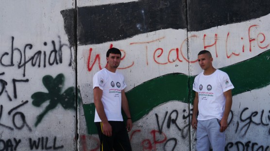
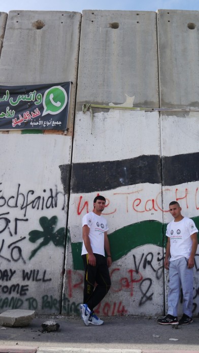
In 2003 the separation wall was built, cutting through the village and dividing its people. Suddenly being identified as ‘blue’ or ‘green’ had significant consequences. Those with green IDs could no longer travel to Jerusalem. Thousands lost their jobs, children were moved to the over crowded schools in Abu Dis and many were unable to visit family members who had blue IDs. In some roads in Abu Dis, the houses on the left fall under East Jerusalem and the residents have blue IDs and the houses on the right are in the West Bank, with green IDs. Half the street can travel to Jerusalem to access services there, and half cannot. The East Jerusalem houses are double the price of the West Bank ones.
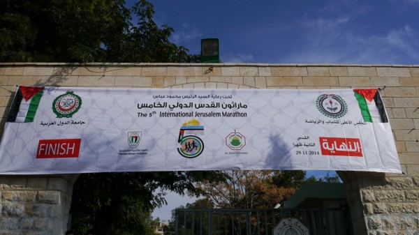
The residents with green ID papers who have been cut off from Jerusalem, have not been affiliated with a new place, leaving them without a city. This was highlighted in the symbolic action called the ‘Jerusalem Marathon’ which took place on Saturday. The race was in fact 2km, from the wall on the eastern edge of Abu Dis to the wall on the west. Over 1000 runners took part to demonstrate their sense of being trapped. The event was followed by speeches and national food, music and dance in defiant celebration of Palestinian culture. There is a full marathon that takes place in Palestine, organised by a group called The Right to Movement. The route is two laps of a 21.km loop as there is nowhere in the West Bank where a full marathon route can be marked out without having to go through a military checkpoint.
Runners at the Abu Dis ‘Jerusalem Marathon’
‘


The Israeli authority has created an identification system by which it controls where people can live, access services and participate in politics. The categories and populations, according to Visualizing Palestine, include:
Jewish Israeli citizens (5.9m): Free to live throughout Israel and in 60% of occupied West Bank. Can vote in Israeli parliament.
Palestinian Israeli citizens (1.3m): Barred from living in 68% of all towns in Israel. Can vote in Israeli parliament.
East Jerusalem Palestinians (0.3m) holding blue ID: Free to travel between East Jerusalem and the West Bank, but are not citizens of Israel and as not living in an occupied territory, are not citizens of Palestine either. Therefore they are given Jordanian citizenship. Applications and renewals of Jordanian passports take place in Jordan, which is expensive to get to. People with blue ID cards are not allowed to leave Israel from Tel Aviv and must travel via Jordan. Cannot vote in Israeli parliament.
West Bank Palestinians (2.3m) holding green ID: Barred from living anywhere but 40% of West Bank. Can’t go to East Jerusalem without permission. Permission categories include medical, work, study and to visit family. Permission is only granted for specific days and spending the night in East Jerusalem is forbidden on all accounts, except medical. Palestinians in the West Bank can apply for a Palestinian passport which can be renewed in Ramallah. They can only leave the country via Jordan. Cannot vote in Israeli parliament.
Gaza Strip Palestinians (1.6m): Barred from living outside Gaza since 2007. Cannot vote in Israeli parliament.
Exiled Palestinians (5.7m): Barred from returning to Israel or occupied Palestine. Cannot vote in Israeli parliament.
Background
In 1949 the Armistice Agreement between Israel and the surrounding Arab countries, monitored by the United Nations, resulted in the Green Line which divided Jerusalem into the west and east. West Jerusalem became part of Israel and East Jerusalem, including the Old City, was part of the Jordanian-held West Bank.

In 1967 Israel declared war on its neighbouring Arab countries and annexed the Old City in East Jerusalem. Palestinians living in this area were given blue ID papers and those living in the occupied territory of the West Bank were given green ID papers. Check points were set up between these areas, but people were still able to travel between them.

Applying for Permission
The process can take up to two weeks and is given for one of the following reasons only: 1) health 2) study 3) work 4) to visit family. The permission will be given for specific days and times and is not granted for overnight stays. Being allowed to cross the border for health reasons is not straight forward, often leading to emergency situations, and getting permission to visit family is rare – usually only granted on holidays. Many people are denied permission without reason, especially young men.

Abu Dis
Before the separation wall was built, East Jerusalem encompassed surrounding villages including Abu Dis, 4km away from the Old City. Although technically people here held different coloured ID papers from people closer to the holy sites, Abu Dis was in reality still an extension of the city. Most people living in Abu Dis went to school or worked in Jerusalem. The residents of Abu Dis were born in the hospitals there and Jerusalem University (University Al’Quds) is situated in Abu Dis.
In 2003 the separation wall was built, cutting through the village and dividing its people. Suddenly being identified as ‘blue’ or ‘green’ had significant consequences. Those with green IDs could no longer travel to Jerusalem. Thousands lost their jobs, children were moved to the over crowded schools in Abu Dis and many were unable to visit family members who had blue IDs. In some roads in Abu Dis, the houses on the left fall under East Jerusalem and the residents have blue IDs and the houses on the right are in the West Bank, with green IDs. Half the street can travel to Jerusalem to access services there, and half cannot. The East Jerusalem houses are double the price of the West Bank ones.
The residents with green ID papers who have been cut off from Jerusalem, have not been affiliated with a new place, leaving them without a city. This was highlighted in the symbolic action called the ‘Jerusalem Marathon’ which took place on Saturday. The race was in fact 2km, from the wall on the eastern edge of Abu Dis to the wall on the west. Over 1000 runners took part to demonstrate their sense of being trapped. The event was followed by speeches and national food, music and dance in defiant celebration of Palestinian culture. There is a full marathon that takes place in Palestine, organised by a group called The Right to Movement. The route is two laps of a 21.km loop as there is nowhere in the West Bank where a full marathon route can be marked out without having to go through a military checkpoint.
Runners at the Abu Dis ‘Jerusalem Marathon’
‘


No comments:
Post a Comment